Boston public schools map switch aims to amend 500 years of distortion
A district will drop the Mercator projection, which physically diminished Africa and South America, for the Peters, which cut the developed world down to size
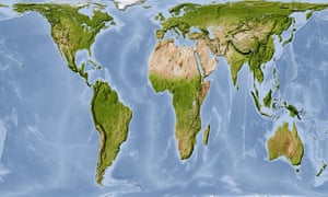
The Gall-Peters projection, which shows land masses in their correct proportions by area, puts the relative sizes of Africa and North America in perspective.
When Boston public schools introduced a new standard map of the world this week, some young students’ felt their jaws drop.
In an instant, their view of the world had changed.
...Three days ago, Boston’s public schools began phasing in the lesser-known Peters projection, which cuts the US, Britain and the rest of Europe down to size. …
Read on, lots of child abuse happening here.
No comments:
Post a Comment